Offshore Windfarm Assets / Academic Industry Cooporation
File
Feasibility Studies
Wind Resource Assessment
Wind resources analysis is the first step to wind farm development, and meteorology of wind is the study of such topic. Taiwan is located between 22-25 degrees in the northern hemisphere. Near-surface wind blows from sub-tropical high pressure belt to Equatorial belt of calms, combined with the effect of Earth rotation, exhibiting N.E. trade wind. This consistent pattern contributes to the main structure of wind resources in Taiwan.
However, an offshore wind farm is significantly smaller in scale than the large-scale meteorological model mentioned above, and regional climate characteristics such as typhoon, sea and land breeze must be taken into account in wind energy assessment. Thus, mid-scale meteorological model is needed. The mid-scale meteorological system introduces the effect of local geomorphology and topography to the overall wind pattern.
Such regional model, when combined with large-scale meteorological model, provides a more detailed regional wind resources assessment. In Taiwan, the trade wind comprise the overall long-term wind pattern. And with the help of regional meteorological observation and assessment, a more detailed regional assessment can be obtained with lower uncertainty and comes with higher temporal resolution.
Wind resources assessment is the result from statistical analysis. To gather valuable data, sensors at the top of met mast are usually designed to be at the hub height, and additional sensors are installed at other heights as well. The met mast and the potential wind farm must be in the same mid-scale meteorological system in order to analyze the overall wind resources in the region.
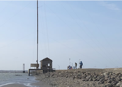
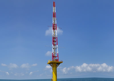
TGC has designed and installed the Fuhai Met Mast offshore Changhua, located at E176481.4, N2660619.9 (TWD97 TM2 coordinate system). Design confirmation, pre-construction verification and on-tower system verification were done by CR Classification Society.
The Met Mast has five anemometers (two at 86.25m, one each at 50m, 30m and 10m height), 4 anemoscopes (at 84.5m, 50m, 30m and 10m height), along with environmental sensors measuring temperature, atmospheric pressure and humidity (at 83.25 m and 10 m height). In addition, a net radiometer and a precipitation meter are installed at 83.25 and 10m height, respectively. For underwater sensors, ADCP and CTD instruments are installed at 20m depth for measuring wave height, current speed, current direction, salinity, sea temperature and underwater pressure.

Metocean Data Analysis
Marine meteorological data acquisition offshore Changhua is done via ADCP (acoustic Doppler current profiler) and CTD (conductivity, temperature and density) installed underwater at the Fuhai Met Mast. ADCP uses the Doppler Effect of sound waves to measure water current velocities over a depth range. CTD measures conductivity, temperature and pressure of seawater.
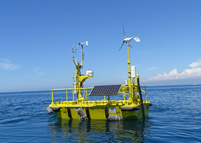
Combined, the two instruments can provide accurate measurements of wave height, wave period, current speed, current direction, sea temperature, salinity and other valuable information on sea condition. In addition, buoys can be deployed to acquire meteorological data with larger spatial coverage. Regular visits must be done in order to retrieve data as well as to calibrate the sensors and re-deploy the buoys to the sea.
The aforementioned meteorological data can be used not only to understand the environmental conditions of the wind farm site but also to assist on weather forecast, construction risk assessment, offshore construction planning, and wind turbine structure design. An example of such implementation is a weather window analysis as reference for Met Mast and wind turbine technicians on future maintenance and construction planning. TGC also collaborates extensively with academic institutions and third-party engineering consultant companies on numerical analysis of the observed results, taken into account wind, wave, water depth and extreme wave numerical models.